Some Historical Sites
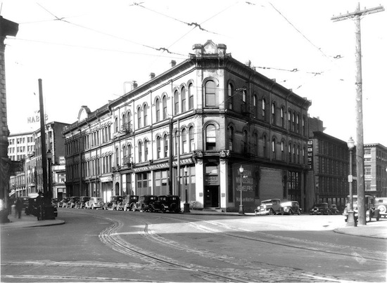
Gastown
"Gassy" Jack Deighton arrived in the Burrard inlet in 1867, the village that was officially known as Granville became more widely known as Gastown, after Gassy Jack. Located on the N. W. Corner of Cambie and Cordova Streets, the Springer-Van Bramer Block was built in 1888 for Captain James Van Bramer and Ben Springer. Captain Van Bramer was a ferry boat captain on Burrard Inlet. Ben Springer was the Manager of the Moodyville Sawmill. Both gentlemen became major real estate investors in early Vancouver. When built, the Springer-Van Bramer Block attracted retail and business occupants as well as social groups such as the Masons and Odd Fellows to the area. Five retail stores were located on the first floor, offices on the second and Oddfellows and Masonic Lodges on the third. The building is also known as the Masonic Temple Building due to that organization’s occupancy of the upper floor between 1888 and 1901. Barkerville
Barkerville was the main town of the Cariboo Gold Rush in British Columbia, Canada and is preserved as a historic town. It is located on the north slope of the Cariboo Plateau near the Cariboo Mountains 80 kilometres east of Quesnel along BC Highway 26, which follows the route of the original access to 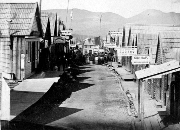
Barkerville, the Cariboo Wagon Road.Barkerville, once the largest city north of San Francisco and west of Chicago, was situated on the western edge of the Cariboo Mountains. It was named after Billy Barker from Cambridgeshire, England, who was among those who first struck gold at the location in 1861, and whose claim was the richest and the most famous.
Barkerville grew up almost overnight, and was a case of "growth via word of mouth". Barkerville grew as fast as word of Barker's strike spread. His claim would eventually yield 37,500 ounces of gold. Before the construction of the Cariboo Wagon Road, people hauled their own supplies to Barkerville, either on their backs or in a pack train. Because supplies were scarce, the prices of even the most everyday items were extremely high. High prices for goods in Barkerville did not ease up until the Cariboo Road had been finished, when goods could be transported by huge freight wagons. Soon, movers of freight boasted that they could pack and carry a set of champagne glasses without any breakage - for a price, of course. More women also came to Barkerville after the construction of the Cariboo Road. |
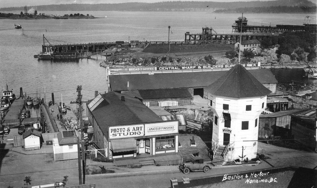
The Bastion
The oldest structure in Nanaimo, the Bastion was originally constructed by the Hudson's Bay Company in 1852 to protect the fledgling mining outpost. The Bastion is a local icon that has endured many challenges since the founding of Nanaimo, British Columbia’s third oldest city. In 1852, the three floors of the Bastion were skillfully crafted using traditional wood working techniques by workers of the Hudson’s Bay Company. Over the years, politics and land deals saw this sturdy wooden fort moved twice. Today it is Nanaimo's most recognizable landmark. While the Bastion’s timbers are original, the interior represents activities of the early mining post from 1853 – 1862. Today, this former Hudson's Bay Company building is a symbol of Nanaimo’s humble beginnings and a testament to our rich West Coast heritage. The Bastion is definitely a "must see" destination for visitors to Nanaimo. 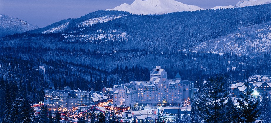
Fairmont Chateau Whistler
The history of Whistler begins many thousands of years ago when the Coast Salish First Nations people inhabited the land, hunting and gathering and living a nomadic lifestyle on the land. The Whistler Valley was an isolated wilderness frequented only by the Lil'wat Nation from the Mount Currie area and the Squamish Nation who lived in an area stretching from present day North Vancouver to the Squamish River watershed and the northern area of Howe Sound. The European history of Whistler reaches all the way back to the 1860s, when British Naval Officers surveyed the area and gave Whistler Mountain the name London Mountain. The name Whistler was used by these early settlers because of the whistling sound made by the western hoary marmots that live among the rocks. The Pemberton Trail from the top of Howe Sound through the Coast Mountains linking the Pacific coast to the Pemberton valley north of Whistler was completed in 1877, encouraging trappers and prospectors to settle. Construction began in 1914 on what was to become the famous Rainbow Lodge on Alta Lake, catering to outdoors people. The highway eventually pushed through from Vancouver in 1965, with Whistler Mountain opening for skiing during the same year. |
How to get thereEmployment |
|
|
British Columbia has a history of being a resource dominated economy, centred on the forestry industry but also with fluctuating importance in mining. Employment in the resource sector has fallen steadily as a percentage of employment, and new jobs are mostly in the construction and retail/service sectors. It now has the highest percentage of service industry jobs in the west, comprising 72% of industry (compared to 60% Western Canadian average). The largest section of this employment is in Finance, Insurance, Real Estate and Corporate Management. Many areas outside of metropolitan areas, however, are still heavily reliant on resource extraction. With its film industry known as Hollywood North, the Vancouver region is the third-largest feature film production location in North America, after Los Angeles and New York City.
|

|
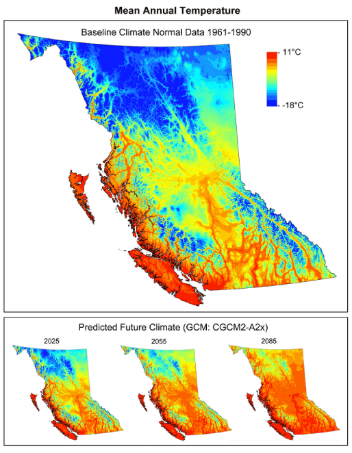
Climate
|
With origins from the Kuroshio Current which merges into the North Pacific Ocean drift current giving coastal British Columbia its mild, rainy oceanic climate, verging on dry-summer mediterranean, subtropical in small pockets. Due to the blocking presence of successive mountain ranges, the climate of the interior of the province is semi-arid with certain locations receiving less than 250 mm in annual precipitation. The annual mean temperature in the most populated areas of the province is up to 12 °C, the mildest anywhere in Canada.
Southern interior valleys have short winters with only brief bouts of cold or infrequent heavy snow, while those in the Cariboo, in the Central Interior, are colder because of increased altitude and latitude, but without the intensity or duration experienced at similar latitudes elsewhere in Canada. The coldest temperature in British Columbia was recorded in Smith River, where it dropped to −58.9 °C, one of the coldest readings recorded anywhere in North America. On the coast, rainfall, sometimes relentless heavy rain dominates in winter because of consistent barrages of cyclonic low-pressure systems from the North Pacific, but on occasion (and not every winter) heavy snowfalls and below freezing temperatures arrive when modified arctic air reaches coastal areas, typically for short periods. Opposite of that, coastal areas are generally milder and dry during summer under the influence of stable anti-cyclonic high pressure. Southern Interior valleys are hot; for example in Osoyoos the July maximum temperature averages 31.7 °C the hottest month of any place in Canada, this hot weather sometimes spreads towards the coast or to the far north of the province. Temperatures often exceed 40 °C in the lower elevations of interior valleys during mid-summer, with the record high of 44.4 °C being held in Lytton on July 16, 1941. The Okanagan region has a climate suitable to vineyards. The extended summer dryness often creates conditions that spark forest fires, from dry-lightning or man-made causes. The exception to British Columbia's wet and cloudy winters is El Niño. During this phase, the jet stream is much further south across North America, therefore winters are milder and drier than normal. Winters are much wetter and cooler under the opposite phase, La Niña. |
|
Additional Photos